What makes a neighborhood successful? For Vasileios Milias, it’s not just about sidewalks or services—it’s about equity in access. With a background in computer science and a passion for human-centered urban data, Vasileios Milias has developed CThood, an interactive tool that helps cities see how accessible and inclusive their public spaces really are. We spoke with him about the path from code to community, and how tools like CThood might shape the future of urban design.

From Algorithms to Urban Encounters
What sparked your interest in urban mobility and pedestrian accessibility, and how did that lead to CThood?
I’ve actually followed a somewhat unexpected path into this field. My background is in Electrical and Computer Engineering, which I studied at the National Technical University of Athens. I specialized in Computer Science and got hooked on programming—it felt like solving compact, clever math puzzles.
After graduating, I realized I wanted to apply those skills to problems connected more directly to people’s behavior and daily life. I wasn’t drawn to writing code for code’s sake—I wanted to use programming as a tool to explore human-centered questions.
That led me to an MSc in Computer/Data Science at TU Delft. There, I met Achilleas Psyllidis—now an Assistant Professor in urban mobility—who introduced me to the world of urban analytics. He later became my PhD mentor, collaborator, and close friend.
Soon, I found myself fascinated by the concept of accessibility. It’s a simple term, but the more you study it, the more complex and multidimensional it becomes. My technical mindset pushed me to keep asking: Can I capture this in an automated way?
I became captivated by the idea of “sense of place”—and the challenge of quantifying how spaces become meaningful. I was also intrigued by how urban models that promoted walking—many of them centuries old—were being revived, reimagined, and suddenly felt modern, even rebellious.
Then I came across William Whyte’s documentary The Social Life of Small Urban Spaces. His observational approach to studying behavior in public spaces really resonated with me. It led me to two core research questions that would shape my PhD: “How can we measure what destinations people can access on foot?” and “How does access shape social encounters?”
During my PhD, I realized that academic papers alone weren’t enough to communicate my methods. I wanted to create something more engaging—something that could invite dialogue beyond academia. That’s when I started building digital artifacts: interactive maps that make my work tangible, visual, and shareable.
First, I developed CTwalk and CTstreets—open-access tools that translated published research into something dynamic and accessible. Both were well received and provided valuable feedback from diverse audiences.
After finishing my PhD, I returned to Athens. CThood was my first “handshake” with the academic and practitioner communities in Greece—an effort to give something back and show how open data can help us evaluate Athens through the lens of the X-minute city model.
What Makes CThood Different
How would you describe CThood to someone unfamiliar with urban planning or data science?
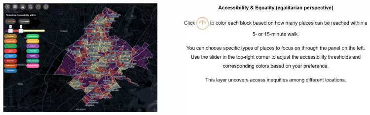
What places can you reach within a short walk? Are parks just around the corner, but grocery stores out of reach? And are basic needs equitably accessible across neighborhoods? That’s what CThood helps explore—through an interactive, visual map.
What makes CThood different from other mapping or accessibility tools?
There are several excellent tools out there right now, which is great to see. For CThood, I’d highlight three key strengths:
First, it’s entirely based on open data, which makes it adaptable and replicable across many cities worldwide.
Second, it integrates equity as a core dimension. Users can explore fairness from two angles: “Are opportunities equally accessible across neighborhoods?” and “Does everyone have access to a minimum set of everyday essentials?”
Third, it’s customizable. Users can define their own thresholds—like how many playgrounds or supermarkets should be reachable—and tailor the tool to reflect their own priorities.

What findings surprised you most in your research so far?
The research is ongoing, but one early takeaway is just how much the narrative can shift based on the types of opportunities you include—say, playgrounds vs. cafés—or the equity thresholds you use.
It might sound obvious, but it’s easy to overlook how those choices shape the results. That’s why I believe studies should be transparent about these parameters—and avoid collapsing everything into a single composite score. It’s important to engage with the complexity without oversimplifying it.
CThood in the Real World: Open Data, Real Impact
Why did you choose to build CThood using open-source tools like OpenStreetMap and OSMnx?
When I first pitched the idea of building an interactive accessibility map for Athens—similar to CTwalk and CTstreets in the Netherlands—people often said, “But we don’t have that kind of data in Greece.” I saw that as an opportunity: Can we build a meaningful tool using only open data? If so, it could be applied to many other cities with similar data limitations.
Choosing the right source was crucial. I picked OpenStreetMap because it’s a credible, widely-used resource in academic research, backed by a strong community. That gave me confidence in its longevity and reliability. In addition, the Python package OSMnx, developed by Geoff Boeing, made it incredibly easy to work with that data. Its thorough documentation meant I could easily collect and process data coming from OpenStreetMap.
Of course, working with open data requires understanding its limits. Before starting, I always ask: what can this dataset support—and what not?
How can CThood support urban planners, governments, or activists? Have others expressed interest? And could it influence real decisions?
This work aims to bridge research and practice. For academics, it offers a replicable method for studying X-minute cities using open data—and a working implementation to explore equity in access.
For practitioners, it offers a lightweight, low-cost tool to support funding decisions, test planning scenarios, or evaluate the accessibility of a neighborhood or development site.
After publishing CThood, several practitioners—both public and private—reached out with ideas. Many didn’t have a clear use case yet, but saw the potential: a bird’s-eye view of what types of places exist, where gaps are, and how to better serve community needs.
In my view, CThood’s biggest contribution is that it opens a conversation. It’s not meant as a finished product—but rather as a flexible tool that can inspire, adapt, and support different urban contexts.

Rethinking Urban Models Through CThood
The “15-minute city” is gaining momentum. What’s most misunderstood about it?
Beyond the conspiracy theories—which I won’t entertain—I think one big misconception is that it’s a universal solution. People imagine a perfect formula that can be copy-pasted across cities. But every city is different. We need to adapt, combine, and experiment with these models based on local realities.
For instance, the 15-minute city assumes people will spend most of their time within their neighborhood. But what does that mean for spontaneous encounters that occur in what Ray Oldenburg called “third places”—those spaces beyond home and work where people meet, socialize, and exchange ideas?
Could encouraging localism unintentionally increase social segregation? That’s a question I explored in my PhD through the concept of Urban Co-accessibility—looking at equity not just in where people live, but in where they can go and who they can meet.
What role do digital tools like CThood play in shaping more inclusive cities?
They can play a powerful role—especially as AI expands. But we still face a gap between “making tools” and “making useful tools.” That disconnect often leads to systems people don’t fully understand or trust.
If digital tools are going to inform real decisions, we need to be honest about what they can and can’t do. That kind of critical thinking is more important than ever—and I hope it becomes the norm.
What’s Next for CThood?
CThood is self-funded for now. Are you planning to expand or collaborate?
Yes. I developed CThood as a postdoc at NTUA, supported by the Laboratory of Transportation Engineering and Prof. Konstantinos Kepaptsoglou. I do have plans to expand CThood to more cities, add features, and collaborate across Europe and the Balkans—but I can’t share details just yet. That said, I’m always happy to talk about these maps—so anyone interested should feel free to reach out!
What would success look like—for CThood, and for your broader work?
Success, for me, is finding that sweet spot where academic research leads to practical, usable tools. I want my work to speak to both worlds—and make a difference not just in journals, but on the ground too.
To explore more expert interviews, click here, and to dive into additional stories on sustainable development in the Balkans, visit this page.