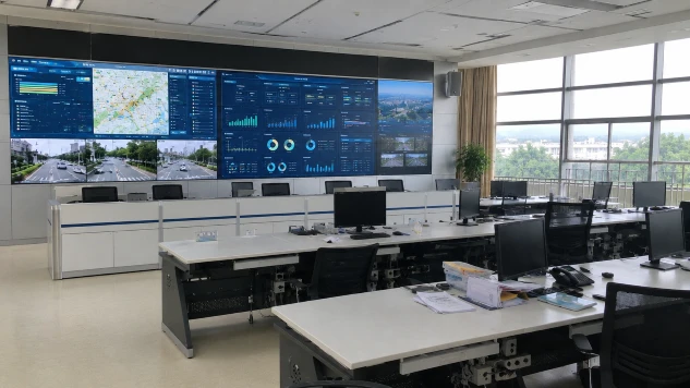
Changzhou’s AI-driven “Cloud Bus” optimises routes in real time, reducing passenger wait times and cutting operational costs. Xuchang’s SaaS traffic control platform, installed at one-tenth the cost of traditional systems, reduced intersection delays by 13.39% and improved rush-hour speeds by up to 15%. Across Europe, cities from Helsinki to Rennes are building federated data platforms and common data spaces, transforming mobility flows, energy grids, and IoT sensor streams into shared public assets governed by GDPR and the Data Act.
This is the smart cities smart enough paradigm as presently imagined: intelligent, efficient, data-driven. It shaves seconds off commutes and euros off bills. It represents the dominant model of urban technological ambition.
But a different question now demands attention. Not whether these systems are smart by their own metrics, but whether they are smart enough for the challenges converging on cities. Enough for heatwaves that turn streets into health hazards? Enough for biodiversity collapse that strips urban ecosystems of resilience? Enough, in short, for a climate-altered planet?
The intelligence gap
The limitation is not technical but conceptual. The digital frameworks underpinning contemporary city-building, Geographic Information Systems, Building Information Modelling, and their evolution into digital twins, share a critical omission. As Borkowski and Wysomirski observe, these tools have been developed primarily for cubature and infrastructure projects, with landscape treated as context rather than system. A systematic review of digital twin research from 2018 to 2024 confirms this pattern: compared with buildings and urban environments, the depth of research in the landscape domain remains significantly lower, despite growing recognition that this represents a critical gap.
This matters because living systems perform measurable work. A mature tree intercepts rainfall, shades surfaces, transpires moisture, sequesters carbon, filters pollutants, and provides habitat. A square metre of healthy soil can absorb hundreds of litres of stormwater. Yet these infrastructural assets remain largely invisible to the digital city.
Others have demonstrated how parametric simulation can calculate vegetation coverage and ecological performance metrics, enabling design efficacy evaluation that was previously impossible within conventional digital workflows.
From concept to method: integrating ecological intelligence
The practical implications of integrating ecological data are becoming visible. Studies on Landscape Information Modelling have proposed full-process frameworks integrating multi-source data collection to achieve high-precision interpretation of environments combining buildings, vegetation, and topography. Others have demonstrated how parametric simulation can calculate vegetation coverage and ecological performance metrics, enabling design efficacy evaluation that was previously impossible within conventional digital workflows.
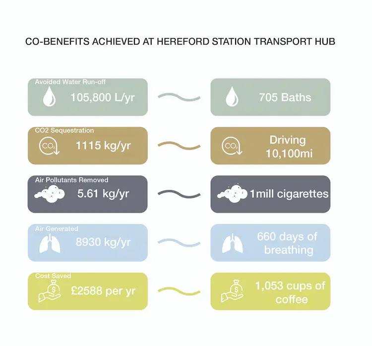
At the Hereford Station Transport Hub in the UK, the LIM Arboris framework embedded ecological data within a multi-modal transport interchange project. The approach integrated microclimate simulations, species-level ecosystem service data, maintenance cost predictions, and environmental cost savings into a single interoperable environment.
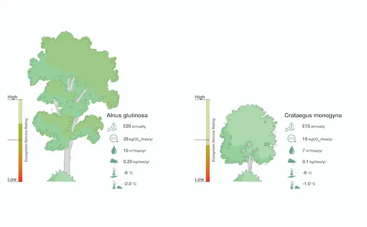
Baseline assessment revealed that a conventional tarmac forecourt, the kind modelled in detail by standard digital tools, reached midday surface temperatures exceeding 55°C during summer months, more than 25°C above ambient air. Vegetation was sparse and fragmented in the existing conditions, providing negligible ecological or climatic benefit. Through iterative scenario testing, the design team evaluated over a dozen tree species against measurable outcomes. Alnus glutinosa demonstrated sequestration rates of approximately 35 kg CO₂ per year according to i-Tree Eco database values. Quercus petraea performed best for avoided water runoff at 1.3 m³ per year and pollution mitigation at 0.2 kg per year. This amounted to an accumulated project benefit of approx. 105,000 litres of water run-off avoided per year, 1115kg/yr of carbon sequestrated and 5.6 kg of pollutants per year removed from the air (Developed by WW+P Architects).
From data to impact: rethinking urban performance
Where a standard BIM model specifies a tree as a generic object with a fixed cost, LIM Arboris models that same tree as a dynamic system with quantifiable outputs: carbon sequestration rate, stormwater interception volume, particulate matter filtration, cooling capacity and habitat value. Where a GIS map shows land cover classification, the framework simulates how alternative planting palettes would perform under future climate scenarios.
These findings are not isolated. Recent research on Landscape Information Modeling applied to urban river wetlands has validated that LIM-based workflows enable automated calculation of quantifiable ecological metrics, including vegetation coverage rates and proportions of riparian areas, through parametric simulation.
Living data layers are a crucial tool to identify suitable, successful, and resilient responses to cities’ environmental and climatic challenges. When tangible data informs design and modelling in early decision-making phases, smart cities become smart in a genuinely holistic sense. Monitoring and feedback loops must include all the elements that give the city its life and pulse.
The governance gap
If integrated approaches exist, why are they not standard? I would argue that the answer is not technical feasibility but political priority. Building data governance frameworks, AI traffic systems, and federated platforms requires massive investment and sustained political will. The EU’s Data Space for Smart and Sustainable Cities initiative, the Horizon Europe mission on Climate-Neutral and Smart Cities, and China’s city-scale AI deployments represent billions in collective investment. Horizon Europe allocates approximately €120 million annually to its Climate-Neutral and Smart Cities mission.
But these resources are directed disproportionately toward systems that optimise flow, traffic, energy, people and goods, rather than systems that sustain life. Every euro spent on a platform that assesses vehicle movements but not tree health is a euro that implicitly deprioritises the infrastructure that will determine liveability under climate stress.
Global policy frameworks make the stakes explicit. The Kunming-Montreal Global Biodiversity Framework commits signatories to restore 30% of degraded ecosystems by 2030 and to ensure spatial planning processes address land-use change—a mandate that requires precisely the kind of high-resolution ecological data that current smart city platforms lack. A city that cannot model its tree canopy, soil health, or habitat connectivity cannot credibly report progress toward these targets.
The Paris Agreement’s global stocktake process requires nations to track adaptation progress, yet adaptation metrics remain underdeveloped, particularly for nature-based solutions in urban contexts. The mandate exists. The tools exist. What is missing is the integration: the decision to embed ecological data as a core, non-negotiable layer of urban digital infrastructure, rather than an optional add-on for sustainability reports.
Toward a living digital twin
A genuinely smart city would not need to choose between traffic optimisation and ecological performance. Its digital twin would model both. It would show not only congestion heatmaps but also the cooling effect of every tree, the water absorption capacity of every verge and the habitat connectivity between every park. It would be a tool for stewardship, not just efficiency.
This is not a speculative fantasy. Recent research demonstrates that integrating BIM, GIS, VR/AR, and IoT technologies for landscape applications can yield measurable economic returns—internal rates of return between 28% and 40% in some cases. The technological building blocks already exist. What remains is the governance framework that mandates their integration, and the political will to treat ecological data as infrastructure rather than ornament.
The alternative is to continue building cities that are brilliantly efficient at moving cars and people but remain blind to the living systems that make urban life possible. That may be smart by the narrow metrics of traffic flow and energy consumption. But as heatwaves intensify, as flood events multiply, as biodiversity loss accelerates, the question will increasingly press: smart, but for what? Smart, but for whom? And above all: are smart cities smart enough?
Read more about