In the face of escalating urban challenges, such as air pollution, inadequate green spaces, and inefficient infrastructure, modern Geographic Information Systems (GIS) offer cities unprecedented tools for comprehensive planning and management. By integrating spatial data, GIS in Serbia enables urban planners to monitor environmental quality, assess land use, and optimize resource allocation with remarkable precision. This capability is particularly crucial for cities like Pančevo, Serbia, where industrial legacies intersect with rapid urbanization, necessitating data-driven approaches to ensure sustainable and equitable development. Leveraging GIS not only enhances operational efficiency but also fosters transparency and public engagement, aligning urban growth with environmental and social objectives. As highlighted by GIS Navigator, GIS plays a vital role in planning and managing urban projects by providing tools for spatial analysis, visualization, and collaboration.
Why policymakers should care about GIS
As Serbian cities grow denser and environmental pressures intensify, traditional planning tools are no longer sufficient. GIS provides the digital foundation for evidence-based governance, enabling cities to integrate spatial data into decision-making processes, allocate resources more efficiently, and engage citizens more transparently. According to UN-Habitat (2008), GIS solutions have become significantly more accessible and affordable, enhancing their utility as planning support systems despite previous constraints of high cost and technical complexity.
GIS is not simply about mapping. It is about governance capacity: the ability to combine data on transport, pollution, infrastructure, and demographics into actionable insights. UN-Habitat highlights that one of the major limitations in many cities is data availability and the skills required to use GIS tools properly; thus, policy must include capacity building and data infrastructure as core parts of implementation plans. For cities across Serbia, this means shifting from reactive responses to preventive strategies, and from fragmented interventions to systemic, long-term planning. Urban planners must ensure data are interoperable; using standard formats (e.g., GeoJSON, CSV) and APIs to allow real-time streaming of air quality sensor data into GIS platforms.
From data to policy action
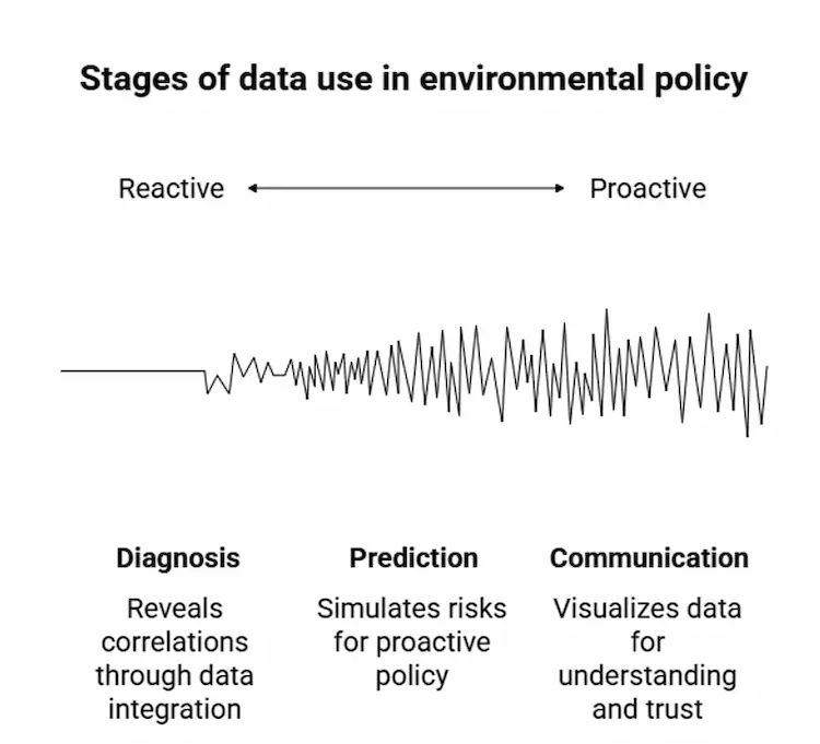
UN-Habitat notes that GIS is valuable in all stages of urban planning: storage, retrieval, visualization, analysis, and modelling of spatial information, which supports informed public discussion and decision-making. GIS supports policymakers in three core ways:
- Diagnosis. Integrating multiple datasets (traffic, health, pollution, green spaces) to reveal hidden correlations, such as links between air quality and school locations. Calibration is essential: sensors should be collocated with reference-grade monitors to ensure accuracy; regular checks and environmental compensation (for humidity, temperature, pressure) are required to maintain reliability.
- Prediction. Using models to simulate future risks, such as pollution spread or flood impacts, enabling proactive policymaking. Using predictive models (e.g. machine learning methods such as decision trees, random forests, convolutional neural networks) improves ability to forecast pollution trends, simulate future scenarios, and support preventive policy measures.
- Communication. Providing visual tools to make complex data understandable for both decision-makers and citizens, thereby strengthening accountability and trust.
European reference points
Cities across Europe have already demonstrated the policy relevance of GIS. Some examples:
- Milan increased green coverage by 10% and reduced urban heat islands by two degrees.
- Copenhagen used GIS to reconfigure public transport networks, cutting travel times by 20%.
- Vienna mapped gaps in green infrastructure, ensuring equitable access across neighborhoods.
These experiences highlight how spatial analytics can inform climate adaptation, equity, and mobility policies. In addition, leading cities integrate IoT sensor networks with GIS for real-time data and visual overlays that highlight pollution hotspots, allowing authorities to respond dynamically to changes.
GIS in Serbia: tools for governance
Pančevo. Environmental risk management
The city of Pančevo, with its strong industrial tradition, has already begun its journey toward more sustainable development. Previously, Pančevo frequently ranked among Serbia’s most polluted cities. A significant milestone was achieved through the efforts of NIS, which reduced air pollution by installing advanced filters in industrial facilities. While a GIS system formally exists in Pančevo, public access remains limited, as we noted in an earlier report. The next crucial step is therefore the full and transparent implementation of GIS technology. By integrating diverse datasets—from air quality to groundwater conditions—GIS can provide a comprehensive foundation for environmental management and decision-making.
Water: Using simulated data for demonstration, GIS analysis of groundwater south of the industrial zone identified critical points with elevated arsenic concentrations. A risk map defined critical, elevated, and moderate zones, enabling authorities to prioritize urgent interventions.
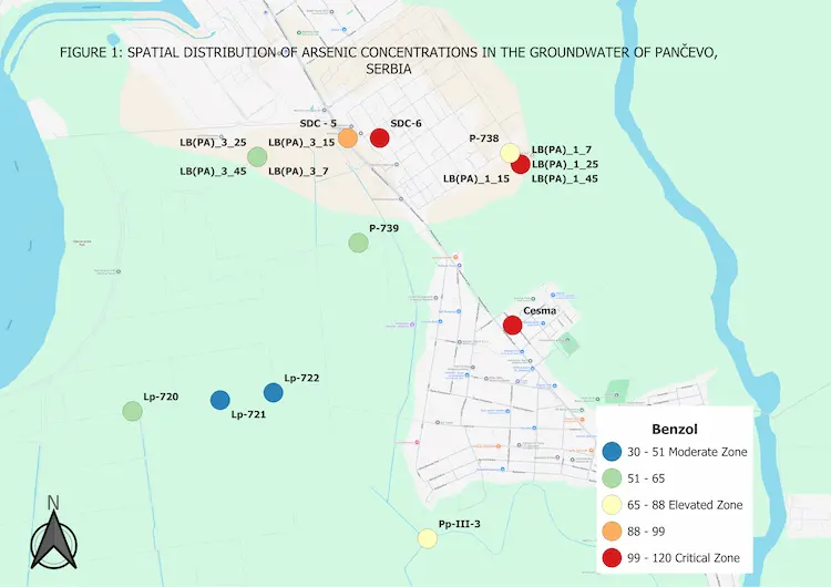
Source: QGIS analysis, simulated arsenic data
Air: GIS platforms can integrate data from air quality sensors (PM2.5, PM10, SO₂) across the city, visualized in real time. This supports:
- Identifying pollution sources. Whether linked to factories, major roads, or heating systems.
- Assessing population exposure. Pinpointing the most affected neighborhoods, as well as schools, kindergartens, and health centers located in risk areas.
- Managing crises. Enabling rapid response and public communication during sudden pollution spikes.
Read more about Pancevo here.
Policy impact: GIS enables Pančevo to align environmental protection with public health priorities, reinforcing ESG standards at the local level. To improve resolution, deploying a distributed network of low-cost air quality sensors across neighborhoods complements fixed monitoring stations, enabling detection of spatial variability in pollution levels.
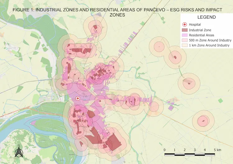
Source: QGIS analysis, OpenStreetMap (QuickOSM)
Belgrade. Transparency and urban planning
Drawing from UN-Habitat’s examples, integrating community participation in data collection is essential: involving citizens in mapping or participatory geographic information systems (PGIS) can help fill data gaps and increase the legitimacy of planning decisions. Through its public Geoportal, Belgrade has opened access to cadastral and planning documents, strengthening transparency and citizen participation. Meanwhile GIS analysis of traffic flows supports more rational infrastructure planning and investment.
Policy impact: GIS fosters open government and evidence-based urban development.
Novi Sad. Energy transition
GIS-based rooftop analysis identified the best locations for solar panel installations, reducing emissions and supporting Serbia’s climate commitments.
Policy impact: GIS links urban planning with national energy transition strategies.
Policy takeaways for Serbian cities
Despite its vast potential, GIS in Serbia remains underutilized today, both as a policy tool and as a means of informing and engaging citizens. Unlocking its value requires a shift in how institutions approach governance and data.
- Institutionalize GIS as a cross-departmental tool, not just a technical platform.
- Invest in data integration to ensure that health, environment, mobility, and infrastructure datasets can be analyzed together.
- Strengthen public communication by using GIS visualizations to engage citizens in policy debates and build trust.
- Align with European standards, ensuring that local initiatives contribute to EU Green Deal, Digital Decade, and sustainable urban development agendas.
Without such efforts, Serbian cities risk falling behind their European peers, which already utilize GIS to advance climate adaptation, mobility, and equity agendas.
Examples from different countries show that GIS in Serbia is not a tool of the distant future but a force shaping the present. By embedding GIS into policymaking, local authorities can not only address immediate environmental challenges but also design resilient, equitable, and future-oriented urban strategies. The next step is clear: treat GIS not as a specialized tool, but as a strategic asset for sustainable development, democratic accountability, and long-term competitiveness in the European urban landscape.